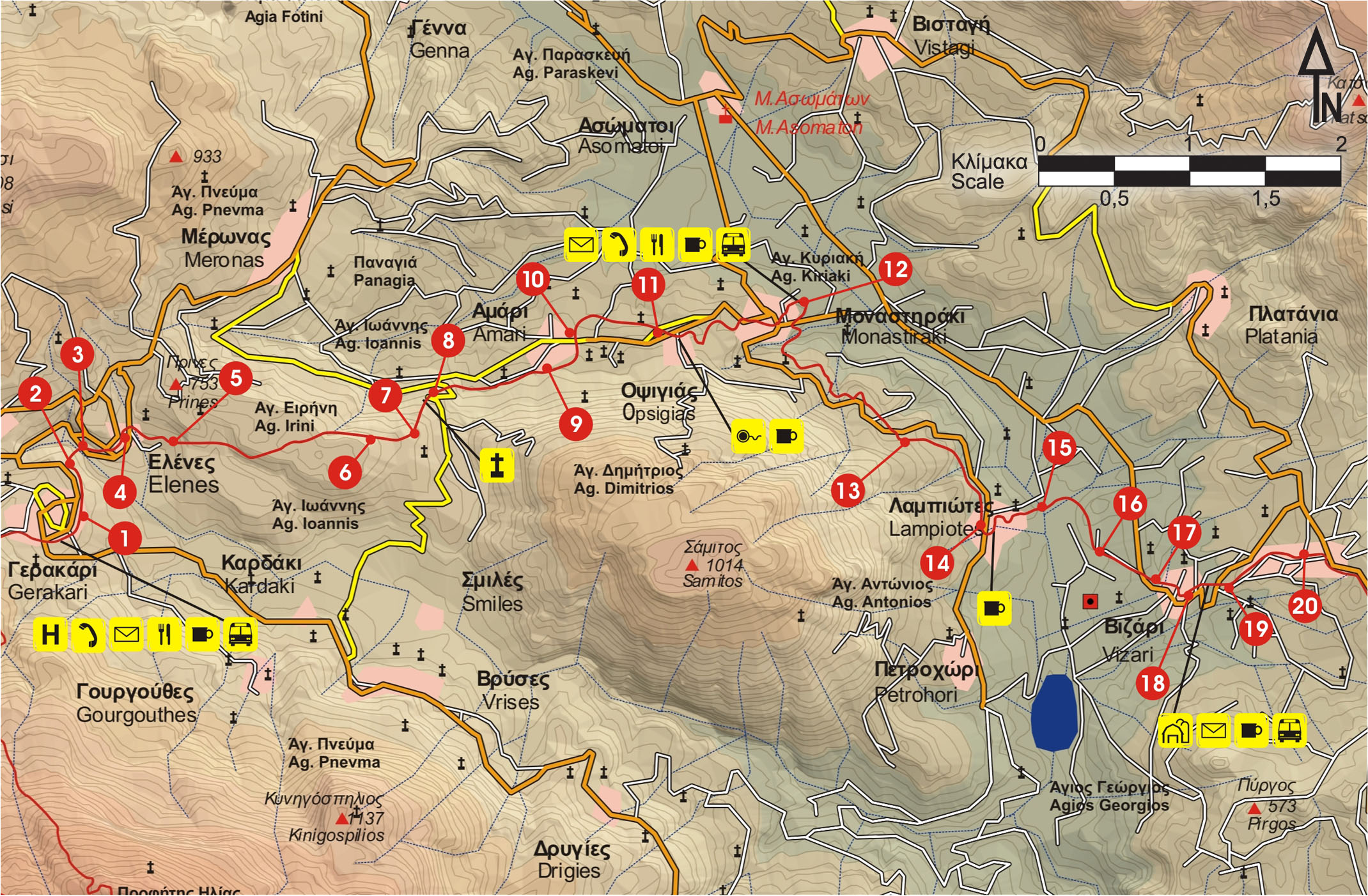
After the Iroon square in Gerakari (1), we continue for 450 m to the northern exit of the village. We then turn right on the dirt road (2), which we leave after 150 m and descend to a vague path that goes along a small ravine (3) and then ascends to the village of Elenes (4).
From the northern edge of the village, we follow the unsurfaced road eastwards. We ignore a right side road and after approximately 400 m, a very vague path (5) begins on our left-hand side, which goes up along the bushy hill slope, to a small oblong flat area. We follow the relatively frequent marks and come to a dirt road (6) on the eastern ridge of the hill that leads down to the east, in a flat area with vineyards; from there, we follow the asphalt road (7) northwards. To the east, the small, characteristic summit of Mount Samitos dominates.
We then reach the chapel of Agios Titos (8), north of which an unsurfaced road begins. We continue eastwards for about 200 m and come to a fenced area; we walk along its northern side, on a path hard to discern, along a bushy slope.
After approximately 1 km, we come to a turn of the path (9) towards the north, which descends to the village of Amàri; following this left-hand turn-off, a few metres further down we come upon a drinking fountain. About 5 minutes later, we arrive at the beautiful historical village of Amari (10), the old capital of the district that has the same name.
Alternatively, from the chapel of Agios Titos we can continue on the asphalt road, turn right at a crossroads and after about 2 km arrive at Amari.
From Amari, we follow the main road eastwards, pass through the village of Opsigias (11) and then reach Monastiraki (12). There, we can visit one of the most important archaeological sites of the Old Palace period of Minoan Crete.
We next follow the main road southwards, reach the chapel of Agia Marina (13) and continue towards the village of Lambiotes (14). Down below, in the valley, we see the reservoir of Vyzari. By now, high above us rises the south-eastern slope of Psiloritis, its summit being easily distinguishable.
From the northern part of the village, we go down the road until the course of the stream (15), which we cross. Then, we continue southwards, initially parallel to the stream, and in 400 m arrive at the reservoir of Vyzari, which we bypass from the north. Halfway to its eastern side, we come to a dirt road (16) which goes towards the east, and after 400 m we reach the main road (17) between Rethymnon and Fourfouras, which we follow eastwards until Vyzari (18).
We continue on the main road for about 450 m, and then come to a dirt road (19), which ascends to the right, passes north of a cemetery and ends at Fourfouras (20), the last village before the climb to the Psiloritis massif.


