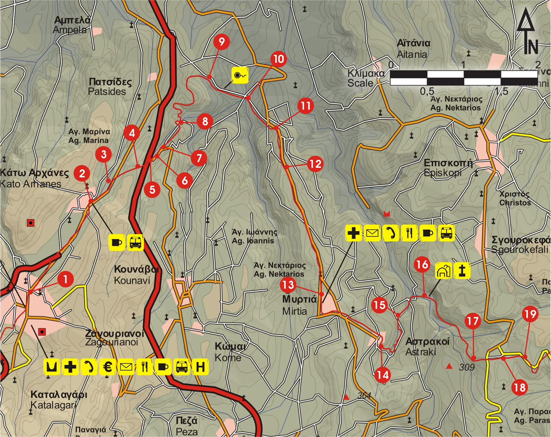
From Ano Archanes (1), we follow the asphalt road, which passes through a small plain with vineyards, until we reach Kato Archanes (2).
From Kato Archanes, we continue for 500 m on the main road, in a northerly direction. We then come to an uphill dirt road (3) on our right-hand side, which we follow for 400 m, to the first turn-off (4); there, we take the right-hand branch.
We walk along the top of a smooth hill for a while, among olive groves. After 100 m, we turn left, descending, and after 20 m we come to an old footpath on our right, which leads us to the main asphalt road (5) down below; we cross it with caution and then descend until we reach the turn of the old main road (6).
Approximately 150 m east of the turn, on the left side of the road, a downhill dirt road (7) can be seen; we follow it for approximately 600 m.
Next, we come to a vague path (8); this passes through a small bushy water course, then meets a dirt road that goes along a slope with vineyards and after 1 km leads us to the main unsurfaced road (9).
We follow a right-hand branch of the road downhill and after 100 m we reach a drinking fountain, under a characteristic fig tree, on our left.
We continue on a cement road, going deep into the valley, until we reach the water course. We cross the bridge (10) and then climb for 40 m, in a northerly direction (on our left). We then turn right into the main unsurfaced road, which we follow straight on for approximately 600 m, to the main road (11).
Next, we turn southwards and continue for a few metres; almost immediately after we leave the main road, following a dirt road uphill on our right, which crosses the western slope of a hill that has a view to the valley that we have just passed. After 800 m, we once more find ourselves on the main road (12), at a location where there is a round cement water cistern.
We continue southwards on the main road, and after 2,5 km we reach the first houses of the village of Mirtia, also known as Varvari (13), place of origin of the author Nikos Kazantzakis.
Opposite the Primary School of Varvari, a downhill road begins, which leads us to the village of Astraki (14); we pass through the village and then follow the narrow dirt road downhill for 400 m. We then turn left and after 30 m we take the right-hand branch of the dirt road (15) and continue downhill towards the water course and the old stone bridge (16).
We use the bridge to cross onto the southern bank of the water course, until we reach an abandoned watermill.
The clear path continues behind the watermill, following the bed of the gorge. Where the gorge splits in two courses, we follow its left branch, leaving the footpath. After 200 m the gorge forks again; we follow its right-hand branch for a while and next we climb up the top of the western slope.
Then, we come to a dirt road (17); after approximately 200 m on it, we come to a main road which we follow in a north-easterly direction for 150 m and then turn right (18), until we reach the Agarathou Monastery (19).


