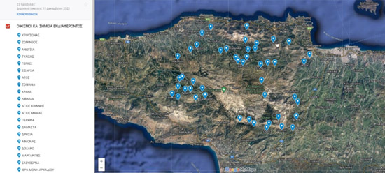
In the framework of the JoInOuT project, developement organisation DAIDALOS S.A worked on the Field Information Services for Geotourism Routes in Psiloritis and more specifically, on the study of planning and implementation of geotourism routes in the Psiloritis Geopark, by collecting and organizing information material for points of interest on 5 routes, namely:
- Provincial - Rural road: Krousonas - Livadi - Zominthos - Nida - Anogeia
- Provincial Road: Tylissos – Gonies – Sisarcha – Anogeia (Nida) – Axos – Zoniana (Damothi) – Krana – Livadia (Lakkos Mygerou connection with Route to Psiloritis) – Agios Ioannis – Agios Mamas – Perama
- Provincial Road: Servili Tylissou (Arolithos) – Boulismeno Aloni – Cave of Glory – Marathos – Damasta – Jeni Gave (Drosia) – Aimonas – Doxaro (Pythes, Vosakou Monastery) – Perama – Margarites – Eleftherna – Arkadi
- Provincial road: Patsos (Faraggi) - Ag. Fotini - Meronas - Gerakari (connection with Yus Kampos tulips) - Kardaki - Nevs Amari - Monastiraki - Petrochori - Fourfouras (route to Pardi - Psiloritis) - Platania (Platanion Route) - Vistagi - Thronos
- Provincial Road: Asites – Prinias – Panasos – Gergeri – Zaros (Ag Nikolaou Gorge Rouva Forest Route) – Vorizia – Kamares
The mapping concerned the environmental (geosites) and cultural reserve (settlements) for the 5 routes of the Psiloritis Geopark, through photographic documentation, while also making extensive video recordings.
In addition, all the necessary information material was analyzed and processed for the digital recording of the routes, data and available information on a cartographic background:

Regarding the creation of a Business Promotion Network on Geotourist Routes and more specifically the recording, recording, processing and digitization of information material for 25 businesses of the Psiloritis Geopark (creating profiles, taking photos), photographs were taken of businesses located on the above georoutes, while at the same time, texts describing them were created, with a basic selection criterion, both their placement on the georoutes and their diffusion in space.
The project entitled "Joint Innovative Activities for Outdoor Tourism" and distinctive title: "JoInOuT", is implemented within the framework of the Action "Cooperative Innovation Formations/SCC" - 2nd Call: Businesses" and is financed by the European Regional Development Fund (ERDF) and by National Resources in the context of the Operational Program "Competitiveness, Entrepreneurship and Innovation (EPANEK)" of the NSRF 2014-2020" (Project code: ΓΓ2CL-0359457).