Mononaftis
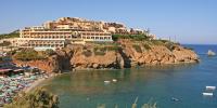
The beach Mononaftis is 23 km from the town of Heraklion and just 1 km from the popular tourist resort of Agia Pelagia.
Malevizi Municipality
The beach Mononaftis is 23 km from the town of Heraklion and just 1 km from the popular tourist resort of Agia Pelagia.
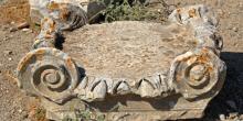
A noteworthy Minoan town was unearthed in the early 20th century, on the site of present-day Tylissos, by the archaeologist Iosif Chatzidakis.
The museum is housed in a stone-built, recently renovated building, in a verdant area very close to Fodele village, where it is believed that the great artis
The whole complex of Arolithos is essentially an open-air museum.

The monastery, located south of Kroussonas, on the foothills of Psiloritis, was one of the richest monasteries during the first years of the era of Ottoman r

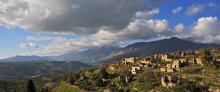
The Ida range dominates the central portion of Crete, occupying a goodly part of the prefectures of Heraklion and Rethymnon, separating the
From Agios Ioannis (1), we take the dirt road which passes through the south-eastern corner of the forest of Rouvas, in an easterly direction. Then, it climbs on the eastern slope and after 4,5 km (approximately 1 hour and 35 minutes), leads us at an altitude of 1.300 m, where it splits (2) into two branches, northwards and southwards.
The southern branch leads to the village of Gergeri.
From Kamares (1), we follow the asphalt-paved, slightly uphill road eastwards; after 2 km, the village of Vorizia comes into view. One of the many gorges of the southern part of Psiloritis opens out on our left.
We begin to descend, until we get to the first houses of the village (2).
This route goes along the eastern and southern foot of Psiloritis, passes through picturesque villages, archaeological sites, Byzantine churches and locations of particular natural beauty, and it also offers the possibility of exploring many different side-roads and hiking routes.
Therefore, if one wishes to make all the suggested stops and try all the secondary routes, one should consider that it is not possible to do everything within only one day.

Sustainable tourism is a development model governed by triple sustainability terms (environmental, social, economic) while giving a new perspective to the countryside, so that it can return to modernity.
