Ancient Lissos
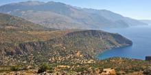
Lissos was the port of ancient Elyros. Its pre-Hellenic name suggests that it was inhabited well before the Doric period.
Kantanos-Selino Municipality
Lissos was the port of ancient Elyros. Its pre-Hellenic name suggests that it was inhabited well before the Doric period.
From the settlement of Agia Irini (1), we cross the stream, pass onto the eastern slope and begin to climb on the old Byzantine path which leads to Omalos, in a north-easterly direction.
The path winds up the ridge. We pass a small saddle and after 2 km we enter a small flat area (2), where we encounter a shepherd’s stone hut and the ruins of another, older one, nearby.
We pass through the flat area and a small dry gully, and continue on the uphill path, with a south-easterly direction, walking on the ridge below and parallel to the main road.
From the square of Koustogerako (1) an uphill cart track begins, which winds up along the impressive slope.
After 2 km of ascent on the cart track, at an altitude of approximately 700 m, we encounter a small plateau (2) and we continue north.
After 1.400 m and having entered a forested area, we meet a right turn-off which we ignore. In the next 100 m we cross a stream and continue for another 600 m, until the end of the dirt road (3).
With Sougia (1) as a starting point, and the plateau of Omalos as a destination, we can choose between two different ways: One of them passes through Koustogerako and the other through the gorge of Agia Irini.
Either way, we initially follow the paved road that crosses the gorge of Sougia.
About 2 km from Sougia, we come to a right turn-off (2); this descends for approximately 800 m, to the point where there is a bridge (3), which we cross. We then continue on an uphill paved road which winds on the pine-covered slope and after 4 km we reach the settlement of Livadas (4).
From Agios Ioannis (1), we follow the slope to the south, constantly having a visual contact with Elafonissi. As soon as we turn south-east, leaving the chapel behind us, a little cove can be seen down below, towards which we descend, after approximately 1200 m. Reaching the cove (2), we see some scattered unfinished marble columns and some carved stones, evidence that the area was used as a quarry in Antiquity.
From the beach of Lissos (1), we begin to ascend for about 500 m, passing through hillside terraces, until the top of the eastern slope (2).
We then follow the trail on the rocky and bush-covered plateau and after 800 m we descend deep into the gorge of Lissos (3).
We follow the gorge for 1 km, until the exit point, where the small harbour of Sougia (4) is located.
Despite the small size of the gorge of Lissos (in height and length), the dense oleander sand the steep rocky slopes, add a special beauty to the route through the gorge.
From Chryssoskalitissa (1), we continue south on a paved road, through small olive groves and shrub-covered landscapes, as well as bare areas, initially without having a visual contact with the sea. After 4,5 km, we reach the beach of Elafonissi (2).
From Elafonissi we follow the coastal path, which is difficult to discern. About 300 m after the makeshift jetty (3), where the small boat from Paleochora docks, we continue for another 700 m, until we reach one of the rare areas of Crete forested with cedars (4).
From the fortress of Pikilassos (1), we begin to descend the steep slope for about 25 minutes, until the impressive gorge of Tripiti.
The shaliness of the slope that the path goes through makes the reverse route very difficult; the ascent requires about 50 minutes.
We follow the stream bed in the gorge to the south, and after about 15 minutes we arrive at its outlet (2).
We leave Loutro (1), climbing up to the old abandoned house on the east side of the settlement.
The very distinct path passes by a shrine and goes along the slope, with the sea down below.
The path which ascends to Anopoli starts at the point where the shrine is.
Having walked on the slope for about 1,8 km, we come to a small cove (2), we then descend to the beach and immediately after we climb towards the ridge of the small cape Pounta (3), where there is a picturesque chapel.
Having the current settlement of Sougia (1) (which is built on the west side of the stream that we cross) as a starting point, we walk along the north boundary of ancient Syia. Then, we begin to ascend the slope in a north-easterly direction, until we find a cart track on our right, which we follow.
The cart track winds round the slope, until a small plateau with terraces and remnants of old structures (2).

Sustainable tourism is a development model governed by triple sustainability terms (environmental, social, economic) while giving a new perspective to the countryside, so that it can return to modernity.
