Imeri (Tame) Gramvousa
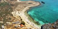
Imeri Gramvousa, one of two rocky islets off the northwest side of the Cape, lies some two nautical miles from the Balos lagoon.&nb
Kissamos Municipality
Imeri Gramvousa, one of two rocky islets off the northwest side of the Cape, lies some two nautical miles from the Balos lagoon.&nb
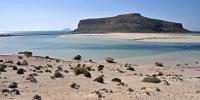
On the northwest coast of Cape Gramvousa, in a bay formed between the lesser capes of Tigani (the Frying pan) and Vouxa (Trypti), lies the sea-lagoon of
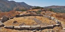
The moment one sets foot at Polyrrinia, one instantly senses that it is a place with a history that can be traced back to the di
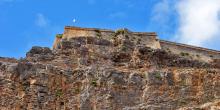
The Venetian fortress of Gramvoussa was built on the unoccupied barren island of Imeri Gramvoussa, opposite the Gramvoussa peninsula, where the a
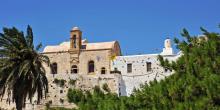
The Monastery of Chrysoskalitissa is built on a rock at the south-west end of Crete.
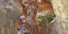
The gorge of Topolia (Topolianó) is located in the inland area of Kissamos, at the western end of the Chania Prefecture.
After Sfinari (1), we move away from the sea, still following the paved road. We head southeast towards the mainland, passing through shrub-covered hills.
After walking for 2 km, we reach the almost deserted village of Ano Sfinari (2), whose residents built the coastal settlement on the shore of the Sfinari bay.
The path then begins to go slightly uphill; after a 6 km walk we reach Kampos (3), the biggest of a cluster of settlements.
We then begin to descend slightly, coming across valleys with plane trees, as well as olive groves, on the hillsides.
From the beach of Lissos (1), we begin to ascend for about 500 m, passing through hillside terraces, until the top of the eastern slope (2).
We then follow the trail on the rocky and bush-covered plateau and after 800 m we descend deep into the gorge of Lissos (3).
We follow the gorge for 1 km, until the exit point, where the small harbour of Sougia (4) is located.
Despite the small size of the gorge of Lissos (in height and length), the dense oleander sand the steep rocky slopes, add a special beauty to the route through the gorge.
1 km after leaving the village of Kefali, we come to a turn-off (1) to the right, which leads to Chryssoskalitissa. The road is now downhill; after2,5 km we arrive at Vathi (2) and after another 1,5 km we cross the small settlement of Plokamiana (3). We follow the west bank of the stream in the valley of Vathi and then walk downhill for 4 km, until we reach the beach of Stomio (4).
3 km after Stomio, we reach the sparsely built settlement of Chryssoskalitissa (5) at a spot where there is a sign that reads: “Elafonissi”.
From Chryssoskalitissa (1), we continue south on a paved road, through small olive groves and shrub-covered landscapes, as well as bare areas, initially without having a visual contact with the sea. After 4,5 km, we reach the beach of Elafonissi (2).
From Elafonissi we follow the coastal path, which is difficult to discern. About 300 m after the makeshift jetty (3), where the small boat from Paleochora docks, we continue for another 700 m, until we reach one of the rare areas of Crete forested with cedars (4).

Sustainable tourism is a development model governed by triple sustainability terms (environmental, social, economic) while giving a new perspective to the countryside, so that it can return to modernity.
