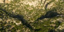
Platania Gorge
Geosite
The gorge located just north of the homonymous settlement is somewhat different from the other gorges in Crete.
Amari Municipality
The gorge located just north of the homonymous settlement is somewhat different from the other gorges in Crete.
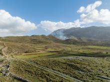
The Gious Kambos is located on the northwestern slopes of Mount Kedros, between the Amari Valley and Spili, about 31 km southeast of Rethymno.

Starting from Patsos and its namesake gorge, the route begins heading towards Meronas, a village with views of Psiloritis and the Amari Valley, and continues to Gerakari, a fertile village built near the plateaus of Gious Kambos, Choni Kambos, and Fteres. Next is Kardaki, followed by Neos Amari, a designated traditional settlement that preserves its folk architecture.
Then, the villages of Monastiraki, Petrochori (on the eastern foothills of Mount Samitos, above the Amari Valley), and Fourfouras (built on the western foothills of Psiloritis) are situated.

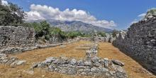
A Greek-Italian excavation team has recently brought to light a very important Minoan settlement of the Old Palace period (19th century BC – 1600 BC).
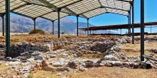
An important Old Palace settlement has been unearthed outside Monastiraki, in the region of Amari.

Syvritos was acity-state that flourished in Antiquity.
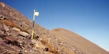
At an altitude of 2.456 metres, the chapel of the True Cross (Timios Stavros) perpetuates the ancient practice of worship in peak sanctuaries.
A remarkable Early Byzantine basilica of the 3rd century AD was unearthed one kilometre east of the village of Vizari, in the district of Amari, on the site
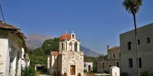
The Monastery of Asomatoi is dedicated to the Gathering of the Angels. It was built in the 2nd Byzantine period in the style of a fortress.

The Ida range dominates the central portion of Crete, occupying a goodly part of the prefectures of Heraklion and Rethymnon, separating the

Sustainable tourism is a development model governed by triple sustainability terms (environmental, social, economic) while giving a new perspective to the countryside, so that it can return to modernity.
