Heraklio

Heraklio Municipality

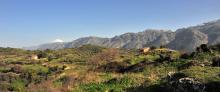
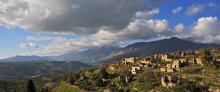
E4.58-59 Rouvas - Mountain Shelter of Oak - Asites

Route or Trail Type
Path Length
14500 m
Difficulty Level
Medium
Path Markers
E4 (Yellow/Black)
Nature Activities
Hiking
Mountaineering
Bird Watching

From Agios Ioannis (1), we take the dirt road which passes through the south-eastern corner of the forest of Rouvas, in an easterly direction. Then, it climbs on the eastern slope and after 4,5 km (approximately 1 hour and 35 minutes), leads us at an altitude of 1.300 m, where it splits (2) into two branches, northwards and southwards.

The southern branch leads to the village of Gergeri.

E4.57 Rouvas - Zaros

Route or Trail Type
Regions
Path Length
8000 m
Difficulty Level
Relatively easy
Path Markers
E4 (Yellow/Black)
Nature Activities
Hiking
Mountaineering
Bird Watching

From Agios Ioannis, we follow the water courseuntil its confluence with the main water course of Rouvas (1). We then walk along the northern bank, until the entrance to the gorge of Agios Nikolaos, also known as Gafari gorge or Rouvas gorge (2).

We cross the water course and pass onto the footpath that has been constructed on the eastern bank of the gorge.

The path by now passes through the main part of the gorge, a little higher up than the water course level, underneath trees.

E4.55-56 Nida - Rouvas

Route or Trail Type
Regions
Path Length
11500 m
Difficulty Level
Relatively easy
Path Markers
E4 (Yellow/Black)
Nature Activities
Hiking
Mountaineering
Bird Watching

From the water spring of Analipsi, we descend to the main dirt road (1), which goes along the western side of the plateau of Nida and heads southwards, towards Poros tis Milias. We follow it for approximately 1.600 m, covering a big part of the plateau, until we come to a side road (2) with an easterly direction, on our left side, which leads us to the valley of Varsamos.

We continue for about 2,2 km, until we get deep into the valley and reach a point where the unsurfaced road branches off (3).

E4.54 Kamares - Zaros

Route or Trail Type
Regions
Path Length
12500 m
Difficulty Level
Easy
Path Markers
E4 (Yellow/Black)
Nature Activities
Hiking

From Kamares (1), we follow the asphalt-paved, slightly uphill road eastwards; after 2 km, the village of Vorizia comes into view. One of the many gorges of the southern part of Psiloritis opens out on our left.

We begin to descend, until we get to the first houses of the village (2).

Gouves-Kasteli-Episkopi-Knossos

This route links a few of the most significant sights of the Heraklion Prefecture and passes through traditional settlements, vineyards and historical monasteries. It is a fairly easy and gentle route. However, museums and other sights demand quite a lot of time; therefore, one may choose to see them individually.

Route or Trail Type
Distance
83 km

Heraklio-Kroussonas-Zaros

This route goes along the eastern and southern foot of Psiloritis, passes through picturesque villages, archaeological sites, Byzantine churches and locations of particular natural beauty, and it also offers the possibility of exploring many different side-roads and hiking routes. 

Therefore, if one wishes to make all the suggested stops and try all the secondary routes, one should consider that it is not possible to do everything within only one day.

Route or Trail Type
Distance
78 km

Houdetsi-Profitis Ilias-Venerato-Dafnes

The “wine roads” of the Heraklion Prefecture lead visitors to age-old vineyards, historical villages, old monasteries, antiquities, contemporary cultural sites, as well as wine factories that are open to the public.

Houdetsi (1) is well hidden on the slope of a beautiful valley. South of the village a hilly landscape with vast vineyards opens up towards the south of the inland area of the Prefecture of Heraklion. 

Route or Trail Type
Distance
68 km