Arhanes-Asterousia

Arhanes-Asterousia Municipality

E4.57 Rouvas - Zaros

Route or Trail Type
Regions
Path Length
8000 m
Difficulty Level
Relatively easy
Path Markers
E4 (Yellow/Black)
Nature Activities
Hiking
Mountaineering
Bird Watching

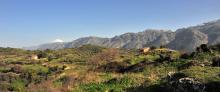
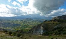
From Agios Ioannis, we follow the water courseuntil its confluence with the main water course of Rouvas (1). We then walk along the northern bank, until the entrance to the gorge of Agios Nikolaos, also known as Gafari gorge or Rouvas gorge (2).

We cross the water course and pass onto the footpath that has been constructed on the eastern bank of the gorge.

The path by now passes through the main part of the gorge, a little higher up than the water course level, underneath trees.

Gouves-Kasteli-Episkopi-Knossos

This route links a few of the most significant sights of the Heraklion Prefecture and passes through traditional settlements, vineyards and historical monasteries. It is a fairly easy and gentle route. However, museums and other sights demand quite a lot of time; therefore, one may choose to see them individually.

Route or Trail Type
Distance
83 km

Houdetsi-Profitis Ilias-Venerato-Dafnes

The “wine roads” of the Heraklion Prefecture lead visitors to age-old vineyards, historical villages, old monasteries, antiquities, contemporary cultural sites, as well as wine factories that are open to the public.

Houdetsi (1) is well hidden on the slope of a beautiful valley. South of the village a hilly landscape with vast vineyards opens up towards the south of the inland area of the Prefecture of Heraklion. 

Route or Trail Type
Distance
68 km