Labyrinth Musical Workshop
The Musical Workshop of Labyrinth was established in 1982 by Ross Daly, and is focused on initiating young musicians to a creative approach towards tradition
Arhanes-Asterousia Municipality
The Musical Workshop of Labyrinth was established in 1982 by Ross Daly, and is focused on initiating young musicians to a creative approach towards tradition
“My father’s family comes from a village called Varvari”, wrote the famous Cretan author Nikos Kazantzakis in his book Report to Greco.
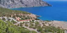
Koudoumas Monastery, which is dedicated to the Virgin Mary, is located on a beautiful coastal area south of Kofina peak.
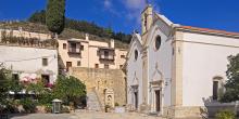
This is one of the largest and richest monasteries on Crete. It flourished during the era of Ottoman rule and is dedicated to Saint George.
The gorge of Kounavi (Kounaviano) is 5 kilometres long in total. The elevation difference between the entrance and the outlet is 180 metres.
The gorge of Astraki (Astrakiano) is quite long (12,5 kilometres), however it is not difficult to pass through.

The gorge of Knossos (Knossano) is 6 kilometres long and,essentially,the natural continuation of the "sacred” mountain of Yiouktas.
From Ano Archanes (1), we follow the asphalt road, which passes through a small plain with vineyards, until we reach Kato Archanes (2).
From Kato Archanes, we continue for 500 m on the main road, in a northerly direction. We then come to an uphill dirt road (3) on our right-hand side, which we follow for 400 m, to the first turn-off (4); there, we take the right-hand branch.
From the eastern exit of the village of Profitis Ilias (1), we follow the asphalt road for 1.700 m. We then turn left (northwards) to a downhill dirt road (2), continuing straight on, northwards, for 300 m. Next, we turn right (eastwards) (3), ignoring any branch roads and after 600 m we turn left (northwards) (4). After 200 m, we take a right turn-off and immediately after it a left one, continuing for 100 m. We then leave the unsurfaced road and walk along an olive grove, towards a stream bed which can be seen down below (5).
From Agios Ioannis (1), we take the dirt road which passes through the south-eastern corner of the forest of Rouvas, in an easterly direction. Then, it climbs on the eastern slope and after 4,5 km (approximately 1 hour and 35 minutes), leads us at an altitude of 1.300 m, where it splits (2) into two branches, northwards and southwards.
The southern branch leads to the village of Gergeri.

Sustainable tourism is a development model governed by triple sustainability terms (environmental, social, economic) while giving a new perspective to the countryside, so that it can return to modernity.
