Festos

Festos Municipality

E4.32 Moundros - Agouseliana

Route or Trail Type
Path Length
11000 m
Difficulty Level
Relatively easy
Path Markers
E4 (Yellow/Black)
Nature Activities
Hiking

From the square at the northern exit of Moundros (1), we follow the road in a rather south-easterly direction and after 150 m we pass by a chapel.

We continue uphill on a distinct path for another 400 m and then we come to a dirt road (2) which we follow southwards, into a small, bare valley, where a stream and the ruins of an old watermill can be seen.

The Asterousia mountain range route

This route connects the most important places of interest of the Asterousia area, such as archaeological sites, settlements, gorges and beaches. One can choose to follow whichever parts of the route that one finds most interesting. It should be noted, though, that the roads which climb up the slopes of the mountain range usually twist and turn, and in some cases they are not paved.

Route or Trail Type
Regions
Distance
84 km

Heraklio-Kroussonas-Zaros

This route goes along the eastern and southern foot of Psiloritis, passes through picturesque villages, archaeological sites, Byzantine churches and locations of particular natural beauty, and it also offers the possibility of exploring many different side-roads and hiking routes. 

Therefore, if one wishes to make all the suggested stops and try all the secondary routes, one should consider that it is not possible to do everything within only one day.

Route or Trail Type
Distance
78 km

Agiofarago

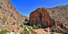
Agiofarago (meaning the Saints' Gorge) is probably the most impressive reasonably manageable gorge of the Asterousia.