Lasithi Plateau

Lasithi Plateau Municipality

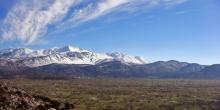
Plateau of Limnakaro

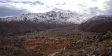
Limnakaro is a small but lovely plateau, at an altitude of 1150 m – best known in climbing circles. Here begin several of the climbing routes on the Lassithi mountains: the main and most frequneted ones lead to the tops of Afendi, Spathi and Lazaro.

Nature Activities
Hiking
Mountaineering
Bird Watching
Mountain Biking

Plateau of Lassithi

At an altitude of 850 m, the Lasithi Plateau is the largest mountain plain in Crete – and the only one occupied all the year round. 

Nature Activities
Hiking
Mountaineering
Bird Watching
Mountain Biking

E4.73 Agios Georgios - Havgas Gorge - Plateau of Katharo

Route or Trail Type
Regions
Path Length
6500 m
Difficulty Level
Relatively easy
Path Markers
None
Nature Activities
Hiking
Mountaineering
Canyoning

From the small cemetery (1) at the eastern exit of Agios Georgios, we follow the dirt road towards the east. After 1.300 m, we come to a junction (2), the right-hand branch of which leads to the plateau of Limnakaro.

On our left lies a big water storage pit; we walk along its eastern bank and 850 m after the Limnàkaro junction we come upon a smaller water storage pit (3), which we bypass on its north-eastern side. We then reach the entrance to the Gorge of Havgas (4), where we see a structure made for channelling the water of the gorge into the water storage pits.

E4.72 Varsami - Selakano

Route or Trail Type
Path Length
7500 m
Difficulty Level
Relatively easy
Path Markers
E4 (Yellow/Black)
Nature Activities
Hiking
Mountaineering

We return to the saddle (1) before the Varsami water spring; from here we continue eastwards, on the main path, and then pass onto a low ridge. A mitato (shepherd’s stone dairy hut) can be seen on the opposite, northern slope, south of the low ridge, where we can take shelter in case of need.

From this point on, we can take a due north-easterly course; after approximately 2 km we reach the summit of Spathi.

E4.71 Limnakaro - Varsami

Route or Trail Type
Regions
Path Length
4500 m
Difficulty Level
Relatively easy
Path Markers
E4 (Yellow/Black)
Nature Activities
Hiking
Mountaineering

Somewhat south of the shepherd’s stone hut (1) which is located at the western side of the plateau of Limnakaro, a cart track continues gently uphill, following the left (eastern) bank of a dry water course. After approximately 800 m, the stream that runs along the western side of the plateau joins with another stream, which runs along the foot of its eastern side.

E4.70 Agios georgios - Limnakaro

Route or Trail Type
Regions
Path Length
5500 m
Difficulty Level
Relatively easy
Path Markers
E4 (Yellow/Black)
Nature Activities
Hiking

We follow the road south of Agios Georgios for 300 m. Slightly before the settlement of Koudoumalia, we come to a complex of agricultural tourism facilities on our left-hand side. There, a secondary road (1), with a southerly direction, begins, which we follow for approximately 500 m. We then come upon a fork and take its left (southern) branch; we continue for 100 m, until we reach an uphill main dirt road (2), which we take southwards for 850 m.

E4.69 Tzermiado - Plateau of Nissimos - Karfi

Route or Trail Type
Regions
Path Length
3500 m
Difficulty Level
Easy
Path Markers
E4 (Yellow/Black)
Red
Nature Activities
Hiking

At the western entrance to the village of Tzermiado (1), where the Health Centre of the Lassithi Plateau area is to be found, a dirt road begins, which snakes on the slope until the small plateau of Nissimos.

Just after the entrance to the plateau, there is a left branch of the road (2) which leads to the foot of the western slope, next to a small chapel (3).

Northwards, in the distance, the summit of Selena can be distinguished.

E4.68 Kato Metochi - Agios Georgios

Route or Trail Type
Regions
Path Length
6000 m
Difficulty Level
Easy
Path Markers
E4 (Yellow/Black)
Nature Activities
Hiking

After the Kato Metochi village square, at the south-eastern exit of the village (1), we leave the asphalt road and enter a dirt road on our left, which passes through the plateau, among cultivated fields. We continue straight on, in a south-easterly direction. After 1.000 m we bypass the settlement of Agios Charalambos (2) to the north.