Soulouksina: The 1st cultural e-bike experience in Crete.
"Follow me to feed the chickens at Soulouksina's", the grandmother used to say.
"But who is Soulouksina, grandma?".
And thus, the story begins...
"Follow me to feed the chickens at Soulouksina's", the grandmother used to say.
"But who is Soulouksina, grandma?".
And thus, the story begins...
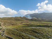
The Social Cooperative Enterprise of Collective and Social Benefit of life society VASILIKATA, located in the Lassithi Plateau, focuses primarily on thematic rural tourism and agritourism. It took its name from the Venetian cartographic engineer FRANCESCO BASILICATA, who was the one who created the first engravings of Crete and placed the Lassithi Plateau on maps. The three main pillars of VASILIKATA are:
The Asites are divided into two traditional settlements, Ano Asites and Kato Asites.
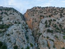
The gorge located just north of the homonymous settlement is somewhat different from the other gorges in Crete.
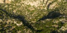
Margarites Gorge is located 30 kilometers from the city of Rethymno and has been formed from limestone rocks 8-10 million years old as a result of the gradua
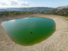
The Vromolimni of Gergeri (the Tomb of Digenis) is located approximately 1.5 kilometers east-northeast of Gergeri, in the Municipality of Gortyna.
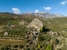
Along the geological path to the Pites tis Grias, a limestone boulder stands prominently within the Neogene rocks of the area.
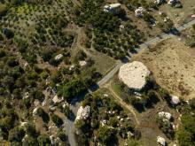
One of the most curious geosites on Mount Psiloritis is undoubtedly the "Pites tis Grias" in the area near the village of Prinias.
The Gious Kambos is located on the northwestern slopes of Mount Kedros, between the Amari Valley and Spili, about 31 km southeast of Rethymno.
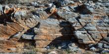
Different types of rocks from the Plakoi limestone unit are found along the route from the settlement of Kato Doxaro to the Monastery of Vosakos.

Sustainable tourism is a development model governed by triple sustainability terms (environmental, social, economic) while giving a new perspective to the countryside, so that it can return to modernity.
