Ha gorge
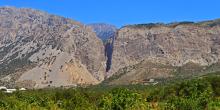
Ha Gorge is considered to be the most imposing gorge of Eastern Crete, owing to its impressive geomorphology.
Ierapetra Municipality
Ha Gorge is considered to be the most imposing gorge of Eastern Crete, owing to its impressive geomorphology.
A small but very beautiful gorge, which is located near the village of Mithi, 22 kilometres west of Ierapetra, at the south-eastern foot of mount
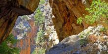
This is one of the most magnificent small gorges of Crete, with impressive rock formations and rich vegetation.

This is an interesting gorge which begins at Orino village and ends up at the area of Koutsouras.
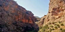
An exceptionally beautiful gorge, with a fairly easy route stretching almost throughout its length.
We walk along the narrow, picturesque alleys of the village of Pefki (1) and follow the asphalt road south-west of the village for approximately 250 m. We then turn left into a rough dirt road (2), which passes through an olive grove and then leads us to a footpath which passes next to an old watermill (3).
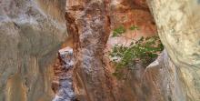
The unsurfaced road runs along the edge of the western wall of the gorge of Pefki for approximately 500 m; next it turns right and descends to the bed of the gorge (4), which features exceptionally beautiful formations and dense vegetation.
We set off at the Dafni village square (1) in a southerly direction. We pass next to the cemetery and take a dirt road that goes left (eastwards), parallel to a steep slope.
Approximately 900 m after the village, at the end of the steep slope, we leave the dirt road and take a vague path (2), in a rather south-easterly direction. After approximately 700 m, we come upon another unsurfaced road (3), which we follow southwards.
From the Orino village square (1), we follow the asphalt road eastwards for 1 km, to a saddle; once there, we turn left into a dirt road (2), which we follow for approximately 1.200 m, and then come upon a left side road (3). At this point, right (east) of the main dirt road we distinguish an old, vague footpath, which we follow.
Within a few metres on the path we come upon an electricity pole; having passed through a small flat area, approximately 20 minutes down the path, we reach a scree area which we cross through. Remnants of an old boundary fence can be seen on our right.
From the central flat area (1) of Thripti, we set off eastwards on a road which presentlyturns north-eastwards and after 500 m we come to a crossroads.
We continue straight for another 450 m, passing along the slope, among scattered farmhouses; then, the uphill road begins to turn eastwards. We ignore a right-hand side road and immediately after a left one and continue for 550 m, still on the main unsurfaced road which winds on the slope.
We walk northwards, on the road that passes through the clusters of houses, from the central area (1) of the Thripti settlement; after 600 m, at its northernmost point, on the right-hand side of a characteristic evergreen oak (2), we go down a few steps that lead us to a dirt road, which we follow for approximately 400 m. We continue straight northwards, just where the dirt roads cross (3).

Sustainable tourism is a development model governed by triple sustainability terms (environmental, social, economic) while giving a new perspective to the countryside, so that it can return to modernity.
